News
Part 1. Typhoons and Heavy Rain in Japan: Business Risks for Global Companies and the Use of Weather Data
2025.10.07
For corporate representatives with operations in Japan and travelers planning to visit, typhoons and heavy rain are major concerns. Many people may wonder: “When is the typhoon season?” “Which areas are most at risk?” “How will it affect business operations or travel plans?”
This article explains the characteristics of typhoons and heavy rain in Japan.
In Part 2, we examine the business risks they pose and highlight how companies can leverage Japan Weather Association’s highly accurate weather data.
Part 2. Typhoons and Heavy Rain in Japan: Business Risks for Global Companies and the Use of Weather Data
Key Points of This Article
- In Japan, typhoons typically approach and make landfall from summer through fall. Especially in August and September, they tend to pass across the country, creating both human and economic risks.
- Shūchū Gōu (集中豪雨, localized heavy rainfall) and Kyokuchi-teki Ōame (局地的大雨, torrential downpours) can trigger river flooding and urban inundation, resulting in severe impacts on logistics and infrastructure.
- By utilizing JWA’s highly accurate, localized weather forecasts tailored to Japan’s unique topography and climate, businesses can anticipate weather-related risks in advance and make swift, informed decisions.
1. Understanding Typhoons and Heavy Rain in Japan
1.1. Typhoons
Typhoon vs. Hurricane vs. Cyclone
Typhoon formation patterns and impacts
Each year, around 25 typhoons form, with approximately 12 approaching Japan and about 3 making landfall. These storms bring heavy rain, flooding, strong winds, high waves, and storm surges. Typhoons also increase the risk of river flooding and landslides often resulting in natural disasters that threaten people’s lives and livelihoods.
In Japan, typhoons typically form and approach between July and October, with many in August and September following tracks that tend to sweep across the country.Flooding at Kansai International Airport (2018)
When Typhoon Jebi (Typhoon No. 21) approached in 2018, storm surges caused extensive flooding across Kansai International Airport, including its runways. The airport was forced to close, which severely disrupted logistics. As a result, deliveries were delayed and the impacts spread widely, causing significant setbacks to corporate economic activities.
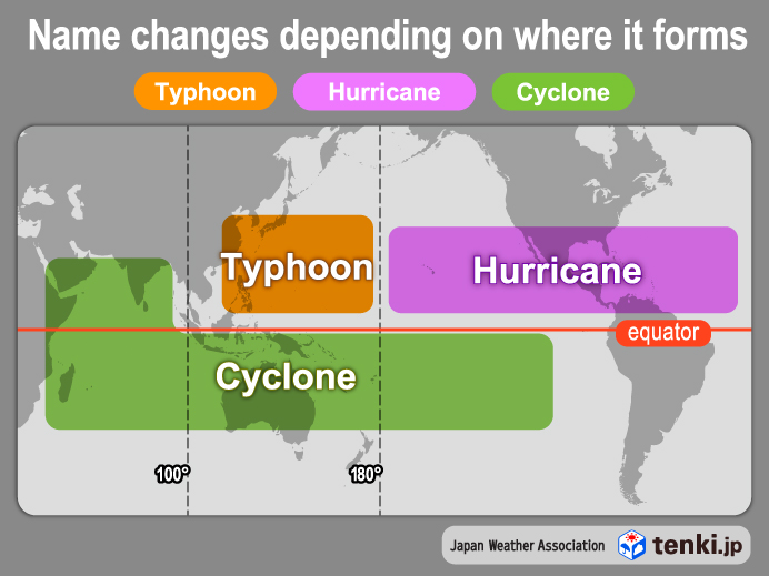
| Typhoon | Hurricane | Cyclone | |
|---|---|---|---|
| Region of forming | The northwestern Pacific west of 180°E longitude and the South China Sea | The North Atlantic, the Caribbean Sea, the Gulf of Mexico, and the northeastern Pacific east of 180°W longitude | The northern Indian Ocean, including the Bay of Bengal and the Arabian Sea |
| Maximum wind speed | Approximately 17 m/s or higher | Approximately 33 m/s or higher | Approximately 17 m/s or higher |
| Season of forming | Typhoons tend to form, approach, and make landfall in Japan between July and October | In North America (Pacific and Atlantic coastal regions and southern areas) and Latin America (Caribbean and Pacific coastal regions), typically from June to November | Mainly from April to December |
1-2. Shūchū Gōu (集中豪雨)
What is “Shūchū Gōu”?
“Shūchū Gōu” refers to heavy rainfall that persists for several hours over the same area, typically caused by factors such as a stationary seasonal rain front or the approach of a typhoon. Total precipitation can range from 100 millimeters to several hundred millimeters. Such rainfall often triggers river flooding and landslides.
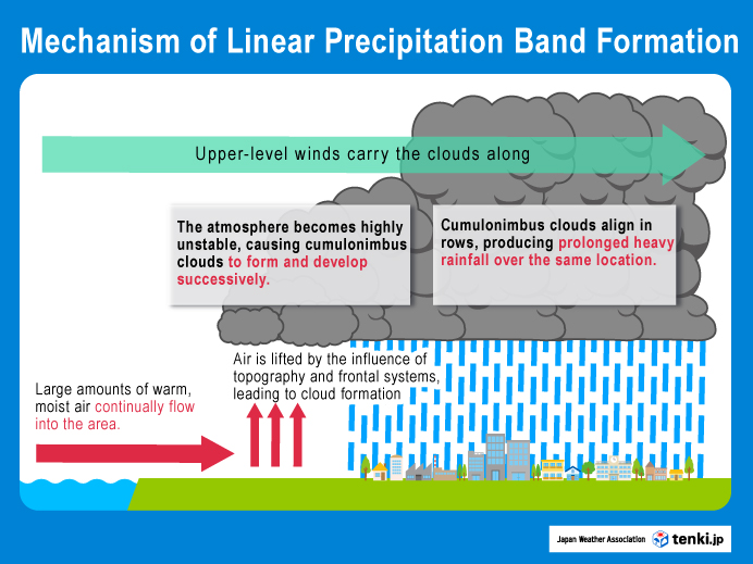
Many cases of Shūchū Gōu are linked to a meteorological phenomenon known as a linear precipitation band (quasi-stationary band-shaped precipitation systems, named ‘senjo-kousuitai’.) In Japan, approximately 60% of Shūchū Gōu events not associated to typhoons are caused by linear precipitation bands. In recent years, the growing frequency of linear precipitation bands is believed to be partly attributed to global warming, and research on their mechanisms and future projections is actively progressing.July 2020 Heavy Rain(2020)
From July 3 to July 31, 2020, a series of Shūchū Gōu (localized heavy rainfall) occurred across Japan, particularly in Kumamoto Prefecture, as well as in Kyushu and the Chubu region. The prolonged heavy rainfall was caused by the stagnation of the seasonal rain front (Baiu front) and the frequent formation of linear precipitation bands. In Kumamoto, Fukuoka, Yamagata, and other prefectures, rivers overflowed, and widespread damage was caused by the heavy rains.
During this “July 2020 Heavy Rain,” there were 86 deaths and 2 missing persons. Housing damage included 1,627 completely destroyed houses, 6,651 partially damaged or half-destroyed houses, and 8,007 houses flooded above and below floor level (as of November 26, 2021). In addition, Kyushu, the Tokai region, and the Tohoku region experienced power outages and water supply disruptions. Lifelines such as communications, along with transportation infrastructure including roads and railways, and agricultural production, also suffered significant damage.
What is a Linear Precipitation Band?
A linear precipitation band is defined as a band-shaped rainfall zone, approximately 50 to 300 km in length and 20 to 50 km in width, accompanied by heavy precipitation. It is created when successive, developed rain clouds (cumulonimbus) organize into clusters aligned in a row, passing over or remaining above nearly the same location for several hours. Normally, a cumulonimbus cloud dissipates within about an hour after releasing rainfall. The same applies to linear precipitation bands; each individual cumulonimbus soon dissipates once it has released rainfall.
1-3. Kyokuchi-teki Ōame (局地的大雨)
What is “Kyokuchi-teki Ōame”?
“Kyokuchi-teki Ōame” refers to torrential downpours that occurs when atmospheric conditions become unstable —often in summer—leading to the rapid development of cumulonimbus clouds and intense precipitation over a limited area. The total rainfall typically reaches several tens of millimeters within a short period. (In everyday Japanese, it is sometimes referred to as a “guerrilla rainstorm.”)
Although the total rainfall amount is less than that of Shūchū Gōu, Kyokuchi-teki Ōame can still bring several tens of millimeters of rain in a very short time over a small area. The sudden influx of water can overwhelm storm drains and cause rapid rises in small and medium-sized rivers, as well as inundation of low-lying locations such as underpasses beneath railways and roads.
Unlike Shūchū Gōu, Kyokuchi-teki Ōame is short-lived, usually lasting no longer than about one hour.
Flooding of Subways and Underground Shopping Areas in Tokyo (2024)
On August 21, 2024, approximately 100 mm of intense rain fell in the vicinity of Minato Ward, Tokyo, within the one-hour period from 6:00 p.m. to 7:00 p.m. This led to the inundation of subway stations and underground shopping areas. The heavy rain also caused elevator malfunctions, suspension of operations at commercial facilities, and manhole covers connected to sewer pipes to be blown off.
2. Outlook for September 2025 and Beyond
According to analyses using the Japan Weather Association’s proprietary forecast models, the number of typhoons approaching Honshu, Hokkaido, Kyushu, and Shikoku from September through October 2025 is expected to be around or above the seasonal average.
For more details, please click: Japan’s Typhoon Season 2025 – Outlook from August Onward
3. Conclusion: Minimizing Business Risks through Forecasts and Preparedness
In Japan, meteorological phenomena such as the rainy season, typhoons, Shūchū Gōu (集中豪雨, localized heavy rainfall), Kyokuchi-teki Ōame (局地的大雨, torrential downpours), extreme heat, thunderstorms, and heavy snowfall frequently lead to natural disasters. Particularly from June to October, heavy rains associated with the seasonal (Baiu) fronts and typhoons, often cause river flooding, landslides, strong winds, storm surges and high waves, resulting in human and economic damage almost every year. Although typhoons and heavy rain are unavoidable natural events, utilizing high-precision weather data enables management to make swift and well-informed decisions that help minimize risks.
For practical examples of how businesses can utilize weather data, please visit:
Part 2. Typhoons and Heavy Rain in Japan: Business Risks for Global Companies and the Use of Weather Data
Please tell us about your challenges. For inquiries, please visit:Contact Us
For more information on the weather complexities in other seasons, please visit:
Why Is Japan’s Weather So Difficult to Forecast?
For the 2024 accuracy verification results of JWA Blend of Models:
2024 Japan Weather Association’s Forecast Accuracy Verification Results