News
Japan’s Typhoon Season 2025 – Outlook from August Onward
2025.08.18
Japan Weather Association (JWA) issued an updated outlook for typhoon activity from August onward.
This update incorporates the latest information into the “2025 Typhoon Trends” first released on May 29, 2025.
Key Points on Typhoons from August to October 2025
- The number of typhoons is expected to be about average.
- The number of typhoons approaching Japan is likely to be average or above average from September to October, with the possibility of a prolonged heavy rain season.
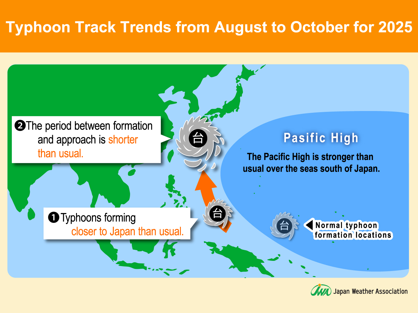
- Typhoons are more likely to form closer to the Japanese archipelago, with a tendency for a shorter time between formation and approach.
What is a Typhoon?
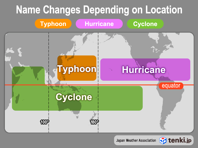
A low-pressure system that develops over tropical seas is called a “tropical cyclone.” Of these, when one develops in the northwestern Pacific (north of the equator and west of 180°E) or the South China Sea, with a maximum sustained wind speed (10-minute average) of approximately 17 m/s (34 knots, Beaufort scale 8) or higher within the low-pressure area, it is called a “typhoon.”
From September through October, Japan enters its autumn typhoon season.
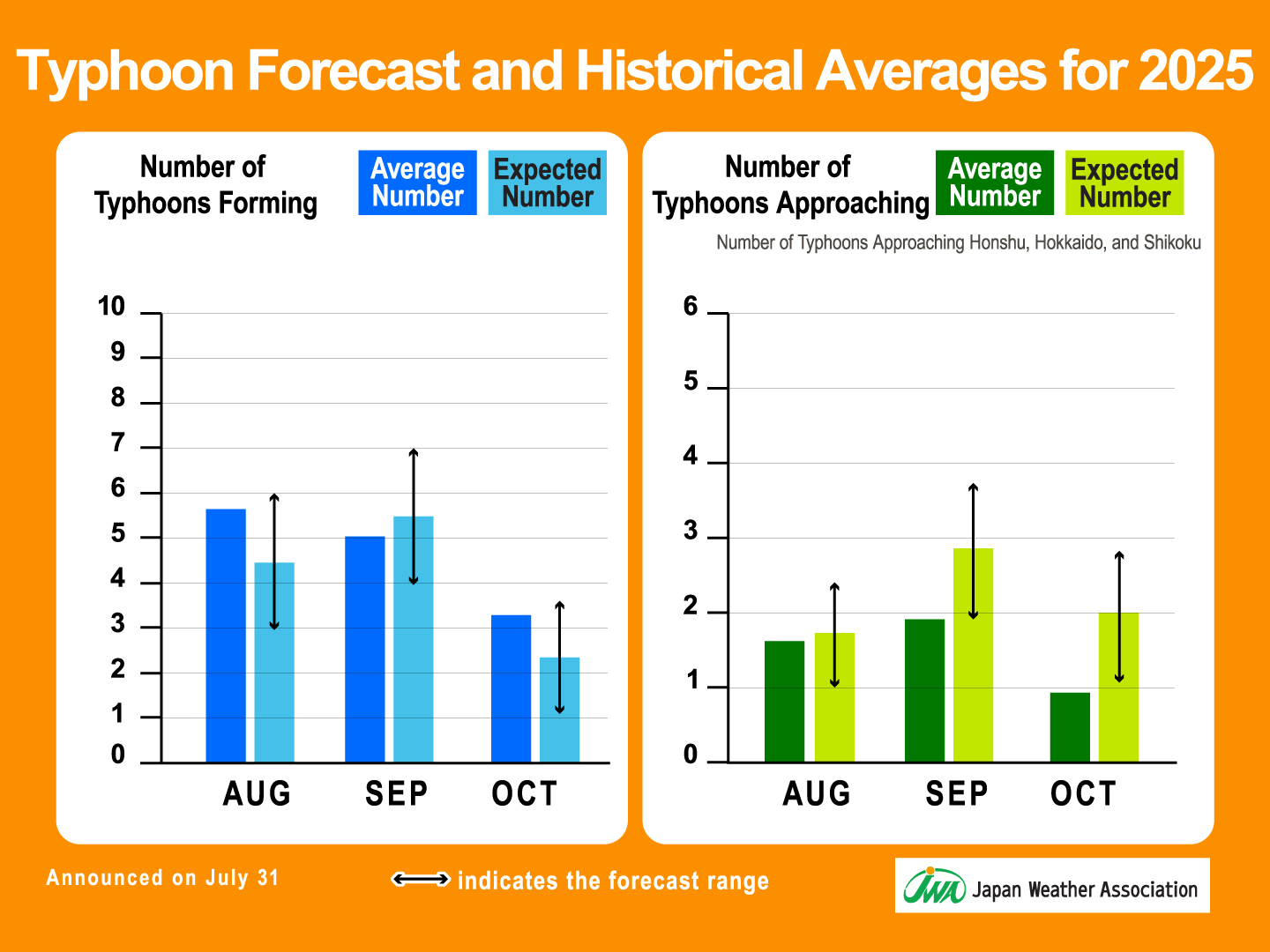
The average number of typhoons forming is 3.7 in July, 5.7 in August, 5.0 in September, and 3.4 in October, showing a tendency for increased activity from July to October.
Starting around July, typhoons tend to follow courses that bring them close to Japan, with September being the month when they are most likely to take tracks that pass through the vicinity of Japan.
Autumn typhoons often accelerate as they approach Japan, and they sometimes intensify the activity of the autumn rain front, bringing heavy rainfall. Every year around this time, such typhoons cause significant damage in Japan.

Number of Typhoons Forming in 2025
Although the first typhoon of 2025 formed later than usual —in June — the number of typhoons in July reached seven, exceeding the average of 3.7.
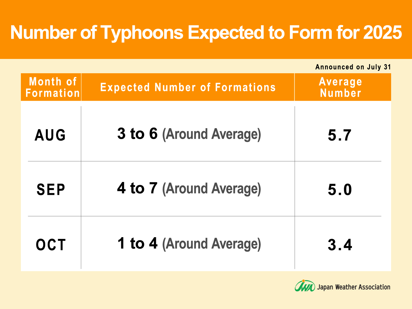
From August to October 2025, the number of typhoons forming is expected to be roughly in line with the average.
Sea surface temperatures are expected to remain high in the main typhoon formation region east of the Philippines. This is likely to lead to enhanced development of cumulonimbus clouds in this area.
While the total number of typhoons forming is forecast to be about average, they are likely to form in areas close to the Japanese archipelago.
Number of Typhoons Approaching Japan in 2025
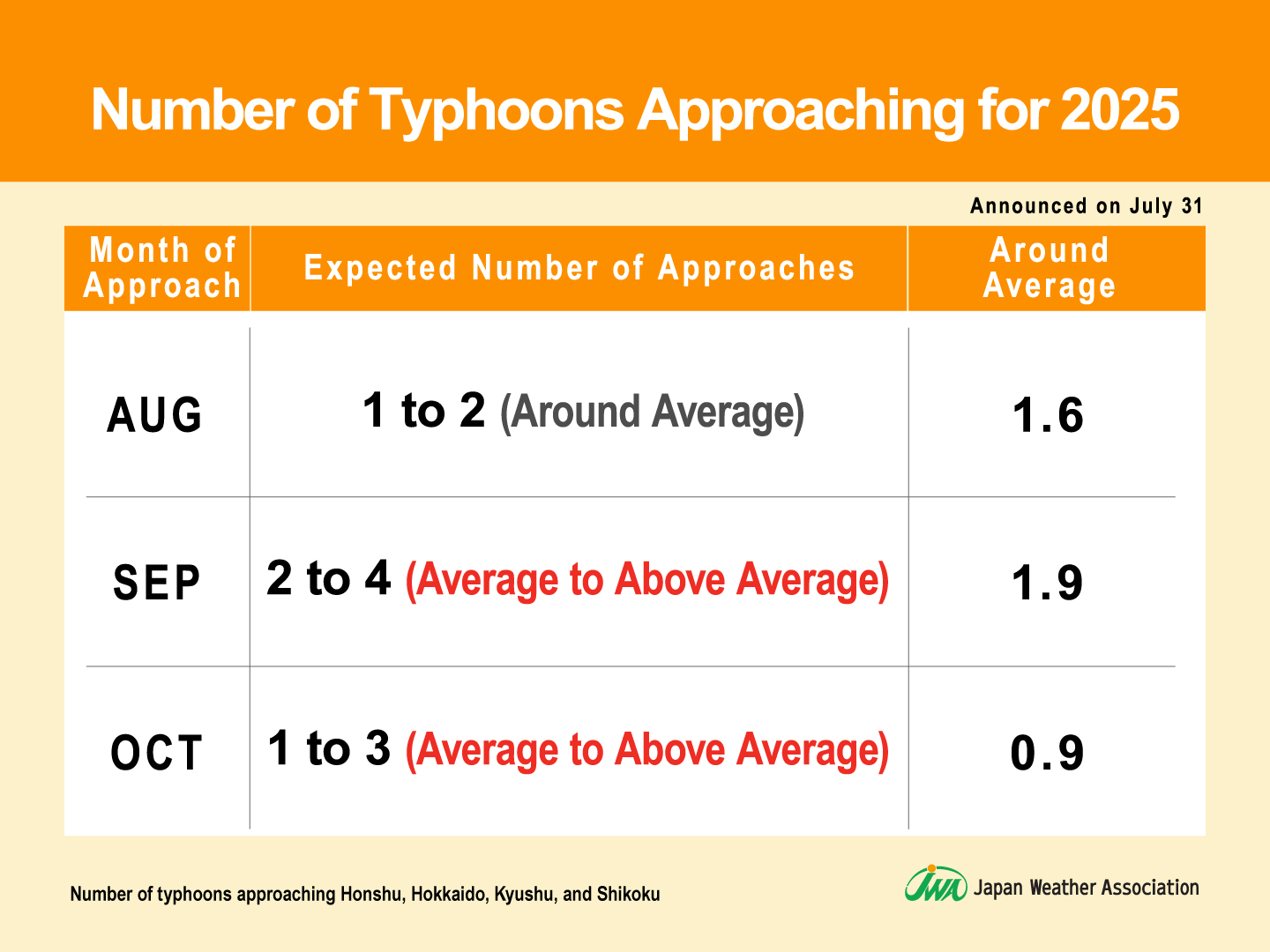
The number of typhoons approaching Honshu, Hokkaido, Kyushu, and Shikoku is expected to be around 1 to 2 in August, which is roughly the historical average, while 2 to 4 are forecast for September, and 2 to 3 for October, which is expected to be around or above average.
If a typhoon approaches Japan and enhances the activity of the autumn rain front, there is a risk of widespread heavy rainfall.
In 2025, the heavy rain season caused by typhoons and the autumn rain front may continue through October, requiring caution until the end of the typhoon season.
Typhoon Trends in 2025
Typhoons tend to approach Japan by skirting along the edge of the Pacific High.
Usually, as autumn progresses, the Pacific High weakens, and typhoon tracks tend to gradually shift toward the seas south of Japan.
However, in 2025, the Pacific High is expected to be stronger than usual over the south of Japan, and its retreat is anticipated to be delayed. As a result, typhoons are likely to continue taking routes closer to the Japanese archipelago through the latter part of the season.
In addition, typhoons are also expected to form farther west than usual, closer to Japan. As a result, the trend of a shorter time between their formation and approach to the archipelago than in usual years is likely to continue.
Please check the latest weather updates for typhoon formations.
* On tenki.jp, the official weather forecast media of JWA disaster prevention information—including “Warnings and Advisories,” “Earthquake Information,” “Tsunami Information,” “Volcano Information,” and “Typhoon Information”—is provided 24/7, 365 days a year. (Only Available in Japanese)
This typhoon outlook announced is an update to the “Disaster Preparedness Report 2025 Vol.1: 2025 Typhoon Outlook” released on May 29, incorporating the latest information.
Preparing for Typhoons in Logistics, Retail, Services, and Agriculture businesses
During typhoon season, typhoon forecasts, along with wind and rain conditions can cause delays or suspensions in transportation systems, affecting logistics, human movement, and consumer behavior.
JWA provides not only general typhoon information but also proprietary data and industry-specific forecasts to support preparedness.
- Probabilistic Scenario-Based Typhoon Forecasts (Only Available in Japanese)
Unlike traditional typhoon forecasts that present a single forecast track, this service offers “probabilistic scenario-based forecasts” with multiple possible tracks.
While the general public typhoon information issued by the Japan Meteorological Agency includes forecast tracks and storm areas up to 5 days ahead, JWA’s scenario-based typhoon forecasts extend up to 10 days ahead. This enables earlier disaster preparedness and response planning. - 2-Year Long-Term Weather Forecasts
Forecasts of typhoon formation and approach are updated quarterly as part of our 2-year long-term forecast.
In addition to typhoon outlooks, we provide monthly forecasts for temperature, precipitation, and the start/end of the rainy season. These insights support informed decision-making in critical business situations, including business planning for the following year, procurement, production, sales, advertising campaigns, and new product development.
For more details, please see:
What are Long-Term Forecasts? JWA’s Proprietary “2-Year Long-Term Weather Forecast” and Its Business Applications Part 1 / Part 2 - Weather Data API
JWA’s weather API is designed to allow developers to access highly accurate weather information for any location. Data such as temperature, humidity, precipitation, snowfall, wind direction and speed, and general weather conditions can be retrieved in a single request through a user-friendly API.
For the overview, please see: Weather API Overview - Logistics-oriented GoStop Management System
This web service provides transport impact risk information caused by weather conditions, supporting decisions that help protect lives and cargo in logistics operations.
The service delivers weather-related transport impact risks up to 6 days in advance, displayed via maps and charts, for expressways, national highways, railways, and maritime routes (ports and navigation routes) across Japan.
For inquiries, please feel free to Contact Us.
* For lightning-related information, see Lightning Report Vol.1 (Only Available in Japanese)
* For information on the lingering summer heat, see “Lingering Heat Expected in 2025: Autumn Likely to Arrive Late – Tokyo to Feel ‘Comfortable’ Around Late September” (Only Available in Japanese)
This document has been compiled based on data that Japan Weather Association deems reliable, however, its accuracy and certainty are not guaranteed.
Please use the information at your own discretion.
Content is subject to change without prior notice.
For any reproduction or duplication of this document, in whole or in part, other than for news reporting purposes, permission from the copyright holder is required. Please contact us in advance.
For product-specific information or consulting services, please also reach out to us directly.