News
Japan’s 2026 Typhoon Outlook: Trends in Typhoon Formation and Approaches to Japan in September and October [Updated July 30]
2026.06.15
Published: June 15, 2026
Last Updated: September 18, 2026
Key Points on Japan’s 2026 Typhoon Trends
- According to preliminary figures as of September 9, 24 typhoons have formed in 2026.
- According to JWA’s forecast, the number of typhoons approaching Japan*1 in September and October is expected to be around normal.
- However, in addition to dangerously high temperatures before typhoons approach, attention is needed because slow-moving typhoons could bring prolonged periods of heavy rain, strong winds, and rough seas, while areas far from a typhoon may also experience heavy rainfall due to active fronts.
For typhoons from summer through autumn 2026, attention is needed not only for the number of typhoons forming and approaching Japan, but also for dangerously high temperatures before a typhoon approaches, the prolonged impacts from slow-moving typhoons, and heavy rainfall in areas far from a typhoon.
Rather than waiting until a typhoon is approaching to begin preparations, businesses should make phased use of information with different forecast lead times, including seasonal trends, multiple track scenarios, and site-specific heavy rainfall and flood risks.
*1 A typhoon is considered to have approached the Japanese archipelago when its center comes within 300 km of a meteorological observatory or weather station in Japan.
Table of Contents
- Current Status of Typhoon Formation and Approaches to Japan in 2026
- Forecast for Typhoon Formation and Approaches to Japan in September and October
- Four Key Points to Watch During the 2026 Typhoon Season (Summer Through Autumn)
- What is a Typhoon?
- Impacts on Business Operations and Preparations Before Typhoon Formation and Approach
- Weather Information and Services to Use at Each Stage
- Conclusion
- FAQ | Frequently Asked Questions About Typhoons in 2026
Current Status of Typhoon Formation and Approaches to Japan in 2026
In 2026, typhoons formed every month from January through May. After that, 2 typhoons formed in June, and 5 in July, 10 in August, and 1 by September 9, bringing the total number of typhoons in 2026 to 24.
The normal number of typhoons forming from January through August is 13.6. As of September 9, 24 typhoons had formed in 2026.
The number of typhoons approaching Japan has also been high. Three typhoons approached Japan in June, well above the normal number of 0.8. In July, 1 typhoon approached Japan, followed by 4 in August and 1 by September 9.
Forecast for Typhoon Formation and Approaches to Japan in September and October
According to an analysis using the “2-Year Long-Term Weather Forecast Model,” developed by JWA using patented technology, the number of typhoons forming is expected to be near normal from August to September, and near or below normal in October.
Meanwhile, the number of typhoons approaching Japan is expected to be near normal in September and October.
| Month of Formation | Number of Typhoons Forming | Normal Value |
|---|---|---|
| September | 4–7 typhoons; around normal | 5.0 typhoons |
| October | 1–4 typhoons; around or below normal | 3.4 typhoons |
| Month of Approach | Number of Typhoons Approaching | Normal Value |
|---|---|---|
| September | 2–4 typhoons; around normal | 3.3 typhoons |
| October | 1–3 typhoons; around normal | 1.7 typhoons |
September and October: Even If the Number of Approaches Is Around Normal, Caution Is Needed
The number of typhoons approaching Japan in both September and October is expected to be around normal. However, a near-normal number of typhoon approaches does not necessarily mean that risks to business operations will also be normal.
Depending on a typhoon’s intensity, track, movement speed, and its position relative to fronts, the impacts of rain, wind, and waves from a single typhoon may be severe and may persist for an extended period.
Four Key Points to Watch During the 2026 Typhoon Season (Summer Through Autumn)
Dangerous Heat May Occur Before a Typhoon Approaches
When a typhoon moves northward from south of Japan, warm air around the typhoon can flow toward Japan. As a result, dangerously high temperatures may occur even before rainfall and strong winds associated with the typhoon affect the area.
In particular, temperatures can rise rapidly in areas where winds blowing toward a typhoon cross mountain ranges and descend on the other side due to the foehn effect. Especially along the Sea of Japan coast, temperatures may rise above normal body temperature, leading to dangerously hot conditions.
*Related article:
What Is the Foehn Effect? Localized Extreme Heat Risks and Heat Countermeasures for Businesses (only available in Japanese)
Slow-Moving Typhoons May Cause Prolonged Impacts
In summer, upper-level winds that steer typhoons are relatively weak. As a result, typhoons may move slowly or follow complex tracks.
When a typhoon moves slowly, heavy rainfall, strong winds, and high waves may persist over the same area for an extended period. In addition, weather conditions may not improve immediately after the typhoon passes.
Heavy Rainfall May Occur Even in Areas Far from a Typhoon
Even in areas far from a typhoon, heavy rainfall can occur when a front remains stationary. Warm, moist air associated with the typhoon can flow into the front, enhancing its frontal activity and increasing the risk of heavy rain.
In such cases, rainfall may intensify before the typhoon’s center approaches, and rain associated with the front may continue after the typhoon has passed. Therefore, businesses should continue to monitor weather information closely, even in areas far from the projected typhoon track.
When monitoring typhoon information, it is important to check not only the position of the typhoon’s center and forecast track, but also the location of fronts, the movement of rain bands, and local weather warnings and advisories.
Watch for Strong Typhoons Approaching Japan in Autumn
According to the Japan Meteorological Agency, El Niño conditions are believed to have persisted since spring 2026.
This autumn, under ongoing El Niño conditions, typhoons in the western North Pacific tend to form farther southeast than usual. If typhoons develop over waters far from Japan, they may spend more time travelling over warm ocean waters before approaching Japan, allowing them to strengthen significantly before reaching the region.
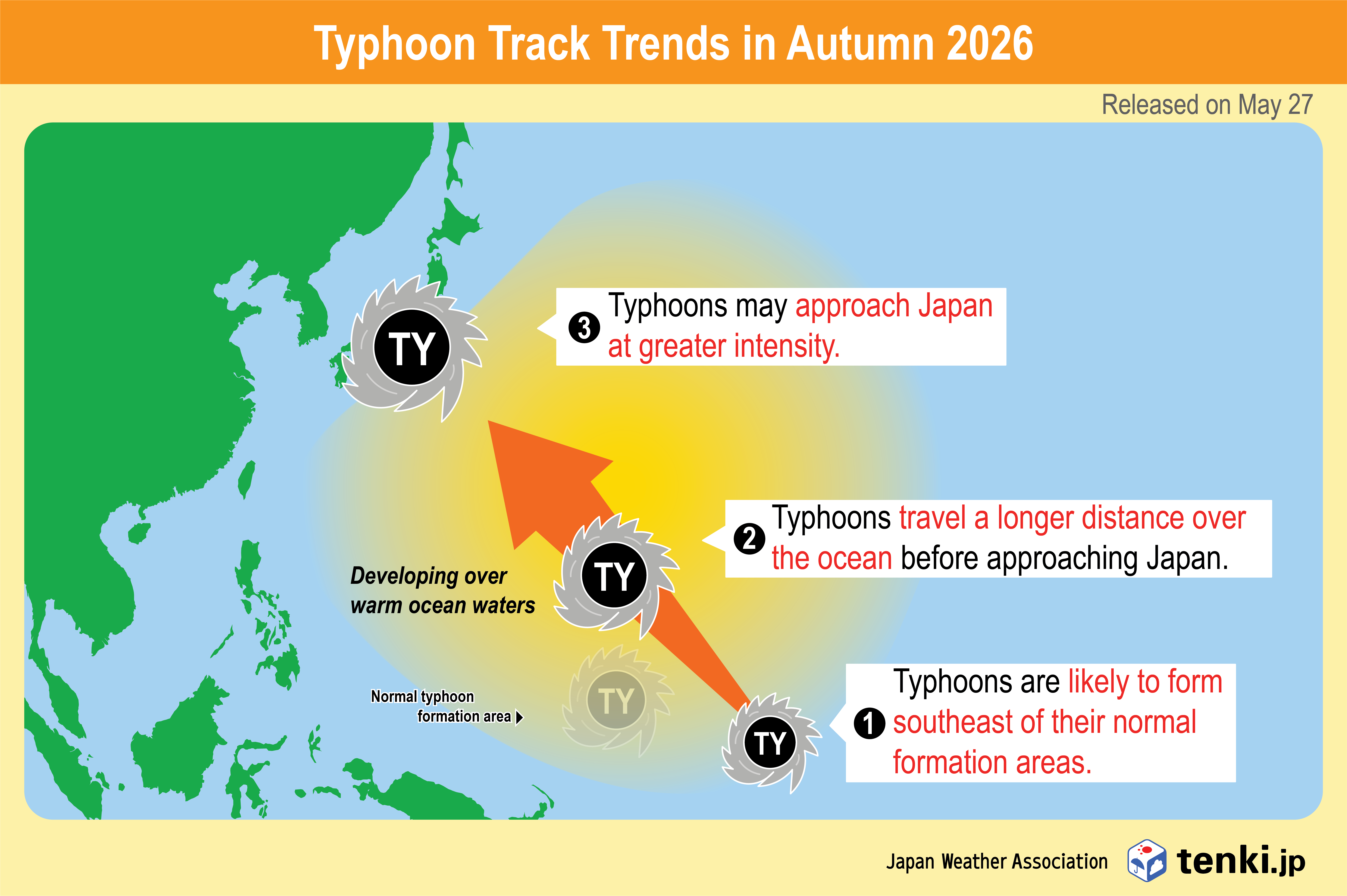
El Niño conditions are expected to continue into autumn. However, the number of typhoons forming and approaching Japan from September to October is expected to be generally around normal. Even if the number of typhoons forming or approaching Japan does not exceed normal, a single typhoon may have significant impacts through rainfall, wind, and waves. Continued attention is therefore needed through the latter half of the typhoon season.
What is a Typhoon?
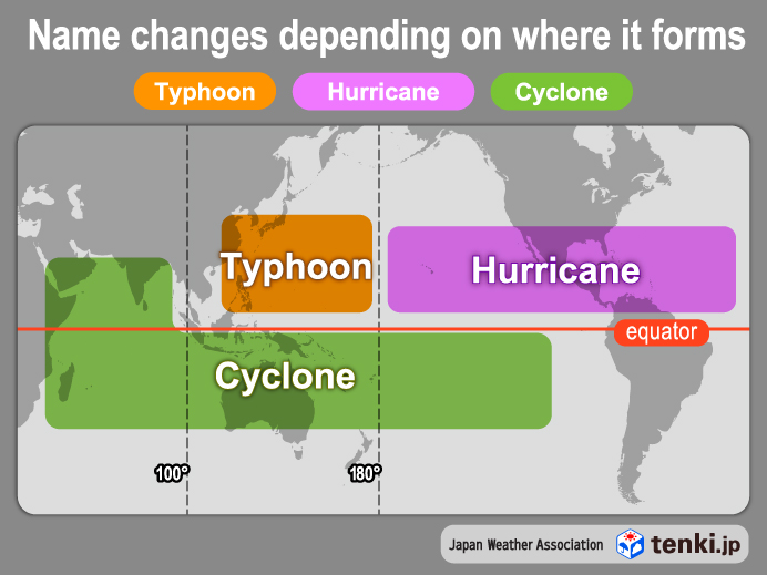
A tropical cyclone is a low-pressure system that forms over tropical or subtropical oceans. Of these, when one develops in the northwestern Pacific (north of the equator and west of 180°E) or the South China Sea, with a maximum sustained wind speed (10-minute average) of approximately 17 m/s (34 knots, Beaufort scale 8) or higher within the low-pressure area, it is called a “typhoon.”
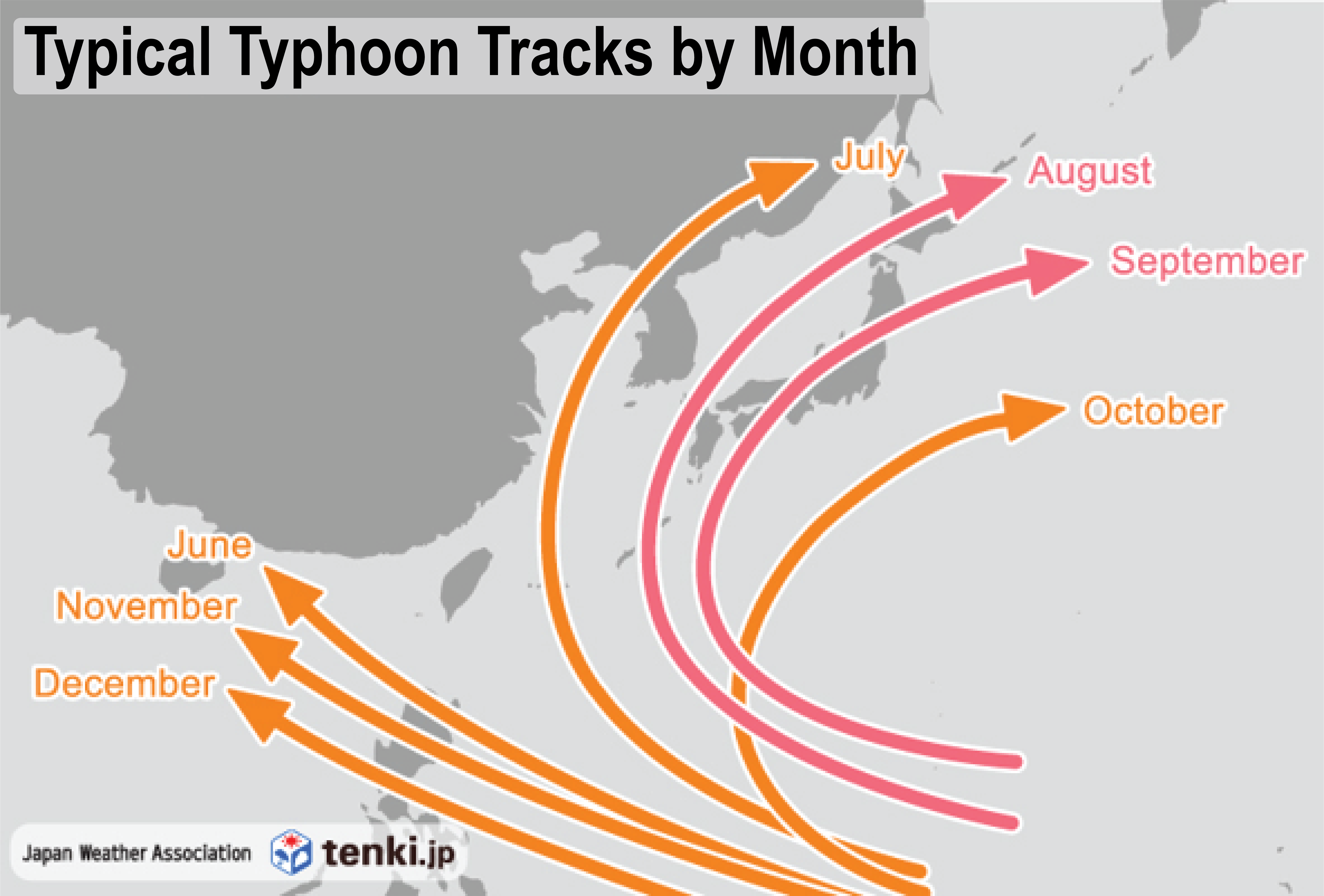
Japan’s autumn typhoon season peaks in September and October.
The average number of typhoons forming is 3.7 in July, 5.7 in August, 5.0 in September, and 3.4 in October, showing a tendency for increased activity from July to October.
Starting around July, typhoons tend to follow tracks that bring them close to Japan, and September is a particularly common period for typhoons to pass near Japan.
Autumn typhoons often accelerate as they approach Japan, and they sometimes intensify the activity of the autumn rain front, bringing heavy rainfall. During this period, significant damage may occur across Japan due to typhoons and the autumn rain front.
For more information on typhoons and heavy rain in Japan, please see:
Typhoons and Heavy Rain in Japan: Business Risks for Global Companies and the Use of Weather Data Part 1 / Part 2
Impacts on Business Operations and Preparations Before Typhoon Formation and Approach
Impacts on Business Operations
Typhoons can affect business operations even before they approach. Depending on a typhoon’s track and timing, companies may need to make decisions across a wide range of activities, including logistics, manufacturing, retail operations, outdoor work, and event management.
From September onward, even if the number of approaching typhoons remains around normal, attention should be paid to the possibility of intense typhoons approaching Japan. When typhoon impacts are expected to be significant, companies may need to make decisions regarding temporary closures, operational suspensions, delivery delays, and event cancellations.
What Businesses Should Check Before Typhoon Formation and Approach
For companies with multiple locations and for businesses that rely on logistics, retail operations, or outdoor work, preparations before typhoon formation and approach are particularly important. These organizations should establish decision-making criteria in advance, taking regional differences in risk into account.
Typhoon preparedness involves more than simply monitoring weather information. It is also important to determine in advance when decisions will be made, who will make them, and what criteria will be used based on that information. If these criteria are unclear, responses may be delayed or inconsistent across different locations.
Weather Information and Services to Use at Each Stage
The weather information that should be monitored for typhoon preparedness differs depending on the stage: before the season, after a typhoon forms, and before it approaches.
It is important to understand seasonal typhoon trends early, review multiple track scenarios once a typhoon forms, and, as a typhoon approaches, assess site-specific risks such as heavy rainfall, flooding, and transportation disruptions.
By using weather information appropriately at each stage, companies can better understand and reduce the potential impacts of typhoons on their operations.
| Timeline | Key Decisions | Useful Information and Services |
|---|---|---|
| Several months before the season to the start of the season | Business planning, inventory planning, workforce allocation, review of disaster preparedness arrangements | 2-Year Long-Term Weather Forecast (only available in Japanese) |
| From typhoon formation to up to 10 days before potential impact | Assessment of multiple track scenarios, initial response planning, preparation for event and logistics decisions | Probabilistic Scenario-Based Typhoon Forecasts (only available in Japanese) |
| Up to 14 days before impact through the day of impact | Site-specific heavy rainfall and flood risk, closure decisions, commuting restrictions | Weather Risk Information for Businesses (only available in Japanese) |
| Up to 6 days before impact through the day of impact | Transportation feasibility, delivery route planning, coordination with shippers and customers | Logistics-oriented GoStop Management System |
Use the “2-Year Long-Term Weather Forecast” for Pre-Season Planning
To incorporate expected typhoon season trends into medium- to long-term business planning, the 2-Year Long-Term Weather Forecast can be used.
In addition to providing more detailed outlooks for typhoon formation and approaches to Japan than those presented in this article, the service offers monthly long-term forecasts for temperature, precipitation, snowfall, sunshine duration, and other variables through reports, data products, and consulting services.
* Service details: 2-Year Long-Term Weather Forecast (only available in Japanese)
For more details, please see:
What are Long-Term Forecasts? JWA’s Proprietary “2-Year Long-Term Weather Forecast” and Its Business Applications Part 1 / Part 2
Use “Probabilistic Scenario-Based Typhoon Forecasts” for Early Response After Typhoon Formation
Typhoon track forecasts inherently involve uncertainty.
When a typhoon has the potential to approach Japan, even slight changes in its projected track can alter the affected areas, timing, and expected intensity of rainfall and winds.
To assess multiple track scenarios after a typhoon forms, Probabilistic Scenario-Based Typhoon Forecasts can be used.
The key features of Probabilistic Scenario-Based Typhoon Forecasts are as follows.
- View three track scenarios with probabilities
The Probabilistic Scenario-Based Typhoon Forecasts service classifies a large number of forecast results into three representative track scenarios and displays each scenario with its probability. By organizing the forecast results into representative scenarios, businesses can more easily compare the uncertainty in the forecast.
- Assess the expected impacts of rain and wind associated with an approaching typhoon
The rainfall forecasts provided for each typhoon track scenario in Probabilistic Scenario-Based Typhoon Forecasts allow the forecast rainfall amounts for each scenario to be compared. Because accumulated rainfall varies depending on the typhoon’s track and movement speed, comparing scenarios helps businesses assess the potential impact of heavy rainfall on individual sites and river basins.
- Continuously monitor from before typhoon formation up to 10 days ahead
Before a typhoon has formed, users can assess the possibility of typhoon formation based on forecasts of the emergence of tropical disturbances that may later develop into typhoons. After a typhoon forms, track scenarios can be checked up to 10 days ahead.
By reviewing forecasts and probabilities across multiple scenarios, businesses can take earlier action regarding logistics, facility operations, retail operations, and event-related decisions.
*Service details and forecast examples: Probabilistic Scenario-Based Typhoon Forecasts (only available in Japanese)
*What Are the Benefits of Viewing Typhoon Tracks in Multiple Scenarios? Business Applications of “Probabilistic Scenario-Based Typhoon Forecasts” (only available in Japanese)
Use “Weather Risk Information for Businesses” to Assess Site-Specific Risks
The impacts of typhoons are not uniform across Japan.
Even with the same typhoon, affected areas vary depending on the storm’s track and the distribution of rain bands.
To identify heavy rainfall and flood risks at individual facilities—such as factories, retail outlets, offices, and logistics centers—Weather Risk Information for Businesses can be used. The service provides site-specific risk information up to 14 days in advance, supporting decisions on closures, commuting restrictions, equipment protection, and flood preparedness measures.
*Service details and use cases: Weather Risk Information for Businesses (only available in Japanese)
Use the “GoStop Management System” for Logistics Decisions
When a typhoon approaches, logistics operations may be significantly affected by road closures, disruptions to rail, port, and airport operations, delivery delays, and the need to ensure driver safety.
To support early decisions on transportation feasibility, route adjustments, and coordination with shippers and customers, the GoStop Management System for logistics can be used. It provides transportation impact risk information up to six days in advance of severe weather, supporting planning and coordination among stakeholders.
*Service details and use cases: Logistics-oriented GoStop Management System
Weather Data API
JWA’s weather API is designed to allow developers to access highly accurate weather information for any location. Data such as temperature, humidity, precipitation, snowfall, wind direction and speed, and general weather conditions can be retrieved in a single request through a user-friendly API.
For the overview, please see: Weather API Overview
Conclusion
As of September 9, preliminary figures show that 24 typhoons had formed in 2026.
From summer through autumn 2026, attention is needed not only to the number of typhoons forming and approaching Japan, but also to dangerously high temperatures before typhoons approach, prolonged impacts from slow-moving typhoons, heavy rainfall in areas far from typhoons, and stronger typhoons approaching Japan later in the season.
Businesses should use information with different lead times, including seasonal outlooks, multiple track scenarios, and site- and route-specific risk information, to make early decisions about operations, logistics, employee commuting, and outdoor work.
FAQ | Frequently Asked Questions About Typhoons in 2026
Q. Will there be more typhoons than normal in September and October 2026?
A. The number of typhoons approaching Japan in September and October is expected to be around normal. However, even if the number of approaches is around normal, impacts may become significant depending on a typhoon’s intensity, movement speed, and its position relative to fronts.
Q. Can a typhoon affect rainfall or heat even when it is far away?
A. Yes. When warm, moist air associated with a typhoon flows into a stationary front, heavy rainfall can occur even in areas far from the typhoon. In addition, before a typhoon approaches, the inflow of warm air and the foehn effect can lead to dangerously high temperatures.
Q. What should businesses watch for regarding typhoons in autumn 2026?
A. Stronger typhoons may approach Japan as autumn progresses. Although the number of typhoons approaching Japan from September to October is expected to be generally around normal, El Niño conditions are forecast to continue into autumn, increasing the possibility that stronger typhoons could approach Japan. Even if the number of typhoons forming or approaching Japan does not exceed normal levels, attention is needed for the possibility that a single typhoon could have significant impacts through heavy rainfall, strong winds, and high waves.
Q. What information should businesses check after a typhoon forms?
A. Businesses should check not only the typhoon’s track, intensity, and expected timing of approach, but also multiple track scenarios, the expected duration of rainfall and wind impacts, flood risks at individual sites, and potential impacts on transportation routes. It is important to use information with different forecast lead times and purposes appropriately, and to begin preparations while there is still flexibility in response options.