News
Why Heavy Rain in Japan Can Become Dangerous: Understanding Linear Precipitation Bands
2026.07.06
Heavy rain in Japan can create serious risks within a relatively short period of time. In particular, caution is required when intense rainfall continues over the same area for around five to six hours or longer. In such cases, the risks of inundation, landslides, river flooding, road inundation, and transportation disruption may increase.
One of the phenomena that can cause this type of heavy rain is a precipitation band known in Japan as a “quasi-stationary band-shaped precipitation system, named ‘senjo-kousuitai’,” also referred to as a “linear precipitation band.” Both “quasi-stationary band-shaped precipitation system, named ‘senjo-kousuitai’” and “linear precipitation band” refer to the same phenomenon.
A quasi-stationary band-shaped precipitation system is a phenomenon in which well-developed cumulonimbus clouds align in a line forming a precipitation area approximately 50 to 300 kilometers long and 20 to 50 kilometers wide, bringing heavy rain to nearly the same area for several hours.
Heavy rainfall associated with linear precipitation bands can increase disaster risk in localized areas within a short period of time. If the rain continues for an extended period, damage can spread over a wider area. In addition, compared with typhoons, the location and timing of linear precipitation band formation are more difficult to forecast, making it challenging for companies to decide how and when to prepare in advance.
This article explains the basic characteristics of linear precipitation bands and outlines how companies can incorporate heavy-rain risk information into operational decision-making.
What You Will Learn in This Article
- What a linear precipitation band is
Learn what a linear precipitation band is, how it forms, and why it can produce intense rainfall over the same area for several hours. - Why preparing for risks associated with linear precipitation bands is difficult
Learn why the location, timing, and duration of linear precipitation bands are more difficult to forecast than typhoons. We also present a case in which JWA successfully identified the potential for a linear precipitation band more than 24 hours before it formed. - What information companies should check to prepare for heavy-rain risks
Learn why it is important to assess not only whether a linear precipitation band is expected to occur, but also expected rainfall amounts, duration, and affected areas. We also explain how weather data tailored to Japan’s unique heavy-rain risks can support earlier preparedness and more informed business decisions.
Table of Contents
- What Is a Linear Precipitation Band? How It Relates to Localized Heavy Rainfall and Torrential Downpours
- Why Preparing for Risks Associated with Linear Precipitation Bands Is Difficult
- What Information Should Companies Check When Preparing for Linear Precipitation Bands?
- How Companies Can Use Heavy-Rain Risk Information
- Conclusion
- Related Articles
- FAQ
What Is a Linear Precipitation Band? How It Relates to Localized Heavy Rainfall and Torrential Downpours
What is a linear precipitation band?
Although there is no universally accepted meteorological definition of a linear precipitation band, the Japan Meteorological Agency (JMA) defines it in its forecasting terminology as:
A linear precipitation area approximately 50 to 300 kilometers long and 20 to 50 kilometers wide, accompanied by heavy precipitation, produced by an organized group of well-developed cumulonimbus that form successively in a line and pass over or remain over nearly the same area for several hours.
Normally, an individual cumulonimbus weakens within about an hour after developing and producing rainfall. The same is true within a linear precipitation band, each cumulonimbus forms, matures, and dissipates in sequence.
However, because new well-developed cumulonimbus continue to form one after another and move over, or remain near, the same area, heavy rainfall can persist for several hours. This prolonged rainfall can significantly increase the risk of flooding, landslides, and other severe disasters.
Details: Size and Formation Mechanism of Linear Precipitation Bands
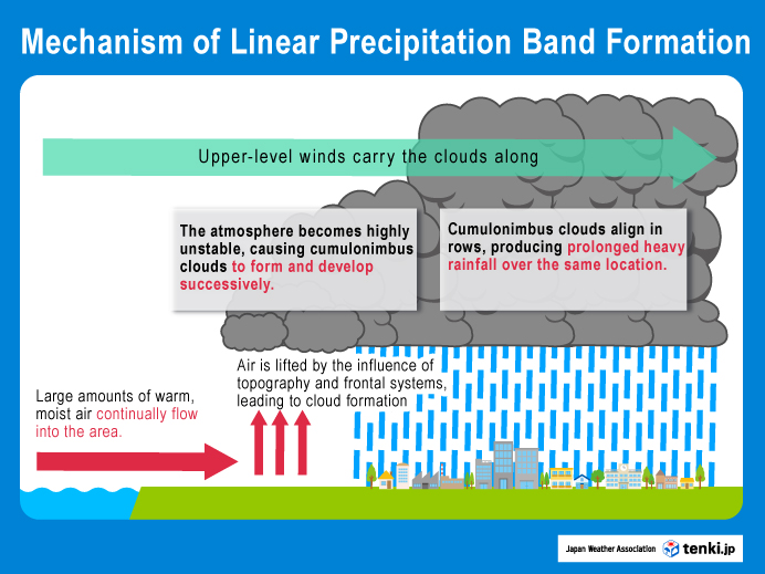
| Item | Description |
|---|---|
| Shape of the precipitation area | A linear band of intense precipitation |
| Typical size | Approximately 50–300 km in length and 20–50 km in width |
| How it persists | Well-developed cumulonimbus repeatedly form in succession, allowing heavy rainfall to continue over the same area. |
| Key risk | When heavy rainfall persists for an extended period, total rainfall accumulates, increasing the risk of flooding and other disasters. |
How It Relates to Localized Heavy Rain and Torrential Downpours
Localized heavy rainfall and torrential downpours both bring intense rainfall, but they differ in their duration, total rainfall, and formation mechanisms. A linear precipitation band is one of the primary meteorological phenomena that can produce localized heavy rainfall. For more information on localized heavy rainfall and torrential downpours, see:
Part 1. Typhoons and Heavy Rain in Japan: Business Risks for Global Companies and the Use of Weather Data
Why Preparing for Risks Associated with Linear Precipitation Bands Is Difficult
When preparing for heavy rain associated with linear precipitation bands, companies need to assess not only whether a band is expected to occur, but also the expected rainfall amount, duration, and the facilities or worksites that may be affected. This section explains three factors that make business decision-making challenging.
Linear precipitation bands can rapidly increase disaster risk in localized areas
Heavy rain associated with linear precipitation bands can rapidly increase disaster risk in localized areas. If intense rainfall continues over the same area for an extended period, accumulated rainfall can increase significantly, potentially causing severe impacts such as flooding, landslides, swollen rivers, and road inundation.
Companies should pay particular attention to the following:
- Whether the heavy rainfall is likely to subside within approximately 2–3 hours, or continue for 5–6 hours or longer, resulting in substantially higher accumulated rainfall.
- Whether the affected area is likely to overlap with company facilities, worksites, or other operational locations
Even when a linear precipitation band forms, the severity of its impacts depends on factors such as rainfall amount and duration. Therefore, companies should not base decisions solely on whether a linear precipitation band is forecast or occurring. They should also evaluate the expected rainfall amount, duration, and geographic extent of the affected area.
Compared with typhoons, their location and timing are more difficult to forecast
The track and expected timing of a typhoon can often be forecast several days in advance, giving companies time to prepare their response. By contrast, heavy rain associated with linear precipitation bands is much more difficult to forecast in terms of its location, timing, and duration. As a result, companies may find it challenging to determine in advance which facilities or worksites should heighten their level of preparedness.
JWA identified the potential for a linear precipitation band more than 24 hours in advance
In the early morning of June 3, 2026, a linear precipitation band formed over Wakayama and Mie prefectures under the influence of Typhoon No. 6. Although the location and timing of linear precipitation bands are inherently difficult to forecast, JWA Blend of Models, JWA’s proprietary weather forecasting system, identified the potential for this event more than 24 hours before it occurred.
For more details on this case and how the JWA Blend of Models supports corporate decision-making for heavy-rain risks, see:
Forecasting A Linear Precipitation Band Associated with Typhoon No. 6 More Than 24 Hours in Advance: How the JWA Blend of Models Supports Heavy-Rain Risk Decision-Making (only available in Japanese)
For more information on the JWA Blend of Models, see:
【Japan Weather Association】JWA Blend of Models (only available in Japanese)
For more information on JWA’s forecast accuracy, see:
2025 Japan Weather Association’s Forecast Accuracy Verification Results
Companies need to make multiple decisions at the facility and worksite level
Even within the same prefecture, the impacts of heavy rain can vary depending on the location of individual facilities, local terrain, disaster risk, and the type of operations being carried out. Therefore, companies should not rely solely on broad-area weather forecasts. Instead, they should assess the risks associated with linear precipitation bands in a way that supports advance decision-making for each facility and worksite.
What Information Should Companies Check When Preparing for Linear Precipitation Bands?
Preparing for linear precipitation bands requires more than simply determining whether one is occurring or expected to occur. Companies should also assess expected rainfall amounts, duration, affected areas, weather warnings, and risk levels to evaluate potential impacts on their facilities and operations as early as possible.
In Japan, the Japan Meteorological Agency issues information whenever a linear precipitation band is detected. These announcements use an automatic detection technology for linear precipitation bands that was developed with the participation of JWA.
JWA’s Technology Related to Linear Precipitation Bands
In June 2021, the National Research Institute for Earth Science and Disaster Resilience, Japan Weather Association, and the Meteorological Research Institute of the Japan Meteorological Agency developed an automatic detection technology for linear precipitation bands associated with extreme heavy rainfall as part of the Cross-ministerial Strategic Innovation Promotion Program (SIP), an initiative led by Japan’s Cabinet Office.
The technology automatically detects linear precipitation bands in areas where disaster risk is rapidly increasing, using rainfall distribution over the previous three hours together with the Japan Meteorological Agency’s hazard distribution information.
This enables the identification of conditions equivalent to Alert Level 4 or higher, the threshold local governments use as a basis for issuing evacuation orders.
To make the information easier for the general public to understand, detected linear precipitation bands are displayed as ellipses.
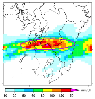
Purple ellipse indicates the automatically detected linear precipitation band
This “automatic detection technology for linear precipitation bands” was implemented in the Japan Meteorological Agency’s Meteorological Information on Significant Heavy Rain, which began operation on June 17, 2021, and is now known as the Weather Disaster Prevention Bulletin (Linear Precipitation Band Occurrence).
For more details, see:
【Japan Weather Association’s Technical Expertise】Automatic Detection Technology for Linear Precipitation Bands Associated with Extreme Heavy Rain (only available in Japanese)
However, companies should not base their decisions solely on whether a linear precipitation band is occurring or forecast to occur.
When heavy rain continues over the same area, the risks of inundation, rising river levels, and river flooding increase in low-lying areas and near rivers.
Therefore, in addition to information on linear precipitation bands, companies should consider multiple sources of information, including warnings and hazard distribution information for heavy rain, river flooding, and landslides; river water-level information; and on-site conditions. These should then be incorporated into the company’s own operational decision-making criteria.
How Companies Can Use Heavy-Rain Risk Information
Responding effectively to heavy-rain risks requires different types of information and different decision-making timelines depending on the business function, such as logistics and transportation, facility and worksite operations, and retail operations. In addition to official disaster-prevention weather information, companies can make earlier and better-informed decisions by using weather information tailored to their own facilities, worksites, and operations.
JWA continues to advance its forecasting technologies to address Japan’s diverse and unique weather conditions, and provides weather risk solutions for a wide range of industries.
- Weather Data API
- Weather Risk Information for Businesses (only available in Japanese)
- JWA was the first organization in the weather industry to develop a proprietary extended long-term weather forecast. For details, see:
What are Long-Term Forecasts? JWA’s Proprietary “2-Year Long-Term Weather Forecast” and Its Business Applications Part 1 / Part 2
Conclusion
- A linear precipitation band is a phenomenon in which well-developed cumulonimbus clouds form successively in a line, producing intense rainfall over nearly the same area for several hours. In Japan, it is one of the most common meteorological patterns responsible for localized heavy rainfall.
- Although linear precipitation bands may dissipate within approximately 2–3 hours, they can persist for 5–6 hours or longer. When this occurs, accumulated rainfall increases significantly, raising the risk of inundation in low-lying areas, river flooding, and landslides.
- Compared with typhoons, linear precipitation bands are much more difficult to forecast in terms of their location, timing, and duration. Nevertheless, JWA Blend of Models identified the potential for the linear precipitation band that occurred over Wakayama and Mie Prefectures in the early morning of June 3, 2026, more than 24 hours before it occurred.
- Preparing for linear precipitation bands requires more than confirming whether one is forecast or occurring. Companies should also assess expected rainfall amounts, duration, and affected areas to make timely operational decisions.
- Through services such as Weather Data API and Weather Risk Information for Businesses, JWA supports companies in preparing for and responding to heavy-rain risks.
Related Articles
FAQ
Q1. What is a linear precipitation band?
A. A linear precipitation band is defined as “a linear precipitation area approximately 50 to 300 kilometers long and 20 to 50 kilometers wide, accompanied by heavy precipitation, produced by an organized group of well-developed cumulonimbus that form successively in a line and pass over or remain over nearly the same area for several hours.”
As well-developed cumulonimbus continue to form successively and pass over or remain nearly stationary over the same area, they can produce intense rainfall over nearly the same location for several hours.
Q2. How can linear precipitation bands affect business operations?
A. When heavy rain associated with a linear precipitation band continues for several hours or longer, the risks of inundation, rising river levels, and river flooding increase in low-lying areas and near rivers. At facilities and worksites located near mountains or steep slopes, the risk of landslides also increases. Road flooding and closures may disrupt transportation and delivery routes.
As a result, companies may need to decide whether deliveries can proceed, whether operations should continue or be suspended, whether operating hours should be shortened or temporary closures implemented, and how best to ensure the safety of employees and customers.
Q3. What information should companies check when there is a risk of a linear precipitation band?
A. Companies should assess not only whether a linear precipitation band is forecast or occurring, but also the expected rainfall amount, duration, affected areas, weather warnings, and risk levels in order to evaluate potential impacts on their facilities and operations as early as possible. JWA provides weather data and services that support companies in preparing for and responding to heavy-rain risks.